
The Surprising Geography Behind Canada’s Population Distribution
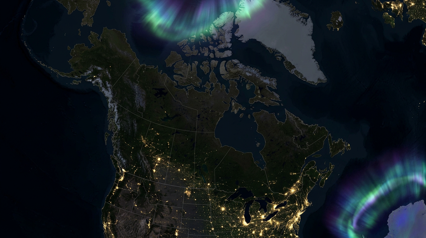
When people look at a map of Canada, one fact often surprises them: most Canadians live remarkably close to the United States border. In fact, approximately 90 percent of Canadians live within 160 kilometres (100 miles) of the Canada–United States border. To outsiders, this can seem strange. After all, Canada is the second-largest country in the world by land area, stretching from the Atlantic Ocean to the Pacific Ocean and northward to the Arctic Ocean.
So why do so many Canadians choose to live near the southern edge of the country?
The answer lies in a combination of geography, climate, history, transportation, economics, and human nature. Canada’s settlement patterns were shaped over centuries by factors that continue to influence where people live today.
Canada’s Vast Size Can Be Misleading
Looking at a map, Canada appears enormous. Covering nearly 10 million square kilometres, it occupies a significant portion of North America. However, much of this land is not easily habitable.
Large sections of northern Canada are characterized by:
- Arctic tundra
- Permafrost
- Boreal forest
- Mountainous terrain
- Limited agricultural potential
- Extremely harsh winters
While these regions are beautiful and rich in natural resources, they are challenging places for large-scale human settlement.
As a result, Canadians have historically concentrated in the relatively narrow southern band of the country where living conditions are more favourable.
Climate Plays a Massive Role
Perhaps the biggest reason Canadians live near the U.S. border is simple: warmer weather.
The further north you travel in Canada, the longer and colder the winters become. Northern communities often experience:
- Winter temperatures below -40°C
- Short growing seasons
- Limited daylight during winter months
- High transportation costs
In contrast, southern Canada enjoys:
- Longer growing seasons
- More moderate temperatures
- Better agricultural conditions
- Easier transportation access
The famous Canadian Prairies, Southern Ontario, and parts of Southern Quebec all benefit from climates that support farming and larger populations.
Even cities that many people consider northern, such as Edmonton, are actually located relatively close to the U.S. border when viewed on a continental scale.
Agriculture Built the Nation
Long before modern highways and airports existed, people settled where food could be grown.
Canada’s most productive farmland is concentrated in southern regions, including:
- Southern Ontario
- Southern Quebec
- The Prairies
- Parts of British Columbia’s interior and Fraser Valley
These fertile regions became the foundation of Canada’s agricultural economy.
Early settlers naturally established farms, villages, and eventually cities where crops could thrive and livestock could be raised.
Many of Canada’s largest urban centres grew directly from these agricultural roots.
The Great Lakes Changed Everything
The Great Lakes system became one of the most important settlement corridors in Canadian history.
The Great Lakes provided:
- Fresh water
- Transportation routes
- Trade opportunities
- Access to markets
Communities developed along waterways because moving goods by water was far easier than transporting them over land.
Today, the Great Lakes-St. Lawrence corridor remains Canada’s most densely populated region.
This corridor includes major cities such as:
- Toronto
- Ottawa
- Montreal
- Quebec City
Together, these metropolitan areas contain a substantial percentage of Canada’s population.
Trade with the United States Drives Population Growth
The United States is Canada’s largest trading partner.
Billions of dollars worth of goods cross the border every year, including:
- Automotive products
- Agricultural goods
- Energy products
- Manufactured goods
- Consumer products
Businesses naturally locate near major transportation corridors and border crossings to reduce costs and improve efficiency.
Major population centres developed around important trade routes connecting Canada and the United States.
Examples include:
- Windsor
- Sarnia
- Vancouver
- Niagara Falls
These communities benefit from direct access to cross-border commerce.
History Favoured Southern Settlement
Canada’s earliest European settlements were established along waterways that connected to the Atlantic Ocean and the interior of North America.
French settlers concentrated along the St. Lawrence River, while later British settlement expanded westward through southern regions.
Railways further reinforced southern development.
When the transcontinental railway was built in the 19th century, it connected communities that already existed in the southern portion of the country.
Cities along these routes grew rapidly because they became transportation and commercial hubs.
Over time, these early advantages compounded, creating the population distribution we see today.
Infrastructure Follows Population
A simple reality of development is that infrastructure tends to be built where people already live.
Southern Canada benefits from:
- Major highways
- Rail networks
- Airports
- Hospitals
- Universities
- Industrial centres
Once these systems are established, they attract even more residents and businesses.
This creates a self-reinforcing cycle where population growth continues in regions that already possess strong infrastructure.
Northern Canada Is Rich but Sparsely Populated
This does not mean northern Canada lacks importance.
The North contains vast reserves of:
- Minerals
- Oil and gas
- Hydroelectric potential
- Forest resources
- Fisheries
Communities across the territories and northern provinces play a vital role in Canada’s economy and identity.
However, resource development often requires fewer permanent residents than agricultural or manufacturing economies.
Modern technology allows companies to operate mines and energy projects with relatively small populations compared to major urban centres.
Some Canadian Cities Are Actually South of Major American Cities
One of the most surprising geographical facts is that several Canadian cities are located farther south than well-known American cities.
For example:
- Toronto is south of several major U.S. northern cities.
- Windsor sits farther south than parts of several U.S. states.
- Most Canadians live at latitudes similar to residents of northern U.S. states rather than in truly Arctic conditions.
This helps explain why Canada’s population is concentrated near the border rather than spread evenly across the country.
The Border Is Not the Destination—The Geography Is
A common misconception is that Canadians live near the border because they want to be close to the United States.
While economic ties certainly matter, the border itself is not the primary reason.
The real explanation is that the same geographic factors that make northern U.S. states attractive for settlement—moderate climates, fertile land, transportation routes, and economic opportunities—also exist immediately north of the border.
Humans naturally settled the most practical and productive parts of the continent regardless of the political boundary.
The Future of Canada’s Population Distribution
Although northern development continues, demographic trends suggest that most future population growth will remain concentrated in southern Canada.
Immigration, urbanization, and economic development continue to favour major metropolitan regions such as:
- Toronto
- Montreal
- Calgary
- Edmonton
- Vancouver
Advances in technology and transportation may encourage additional growth in northern regions, but geography remains a powerful force that continues to shape where Canadians choose to live.
Final Thoughts
The reason so many Canadians live close to the U.S. border is not a coincidence. It is the result of centuries of geographic realities, historical settlement patterns, economic opportunities, transportation networks, and climate considerations.
Canada may stretch to the Arctic, but the country’s most hospitable farmland, major waterways, transportation corridors, and economic centres are concentrated in the south. As a result, nearly nine out of ten Canadians live within a relatively short distance of the international border.
Far from being unusual, this pattern reflects the natural relationship between people and geography. Canadians live where the land, climate, and opportunities have made life most practical for generations—and that happens to be close to the longest international border in the world.
Leave a Reply