
Weather & Agriculture
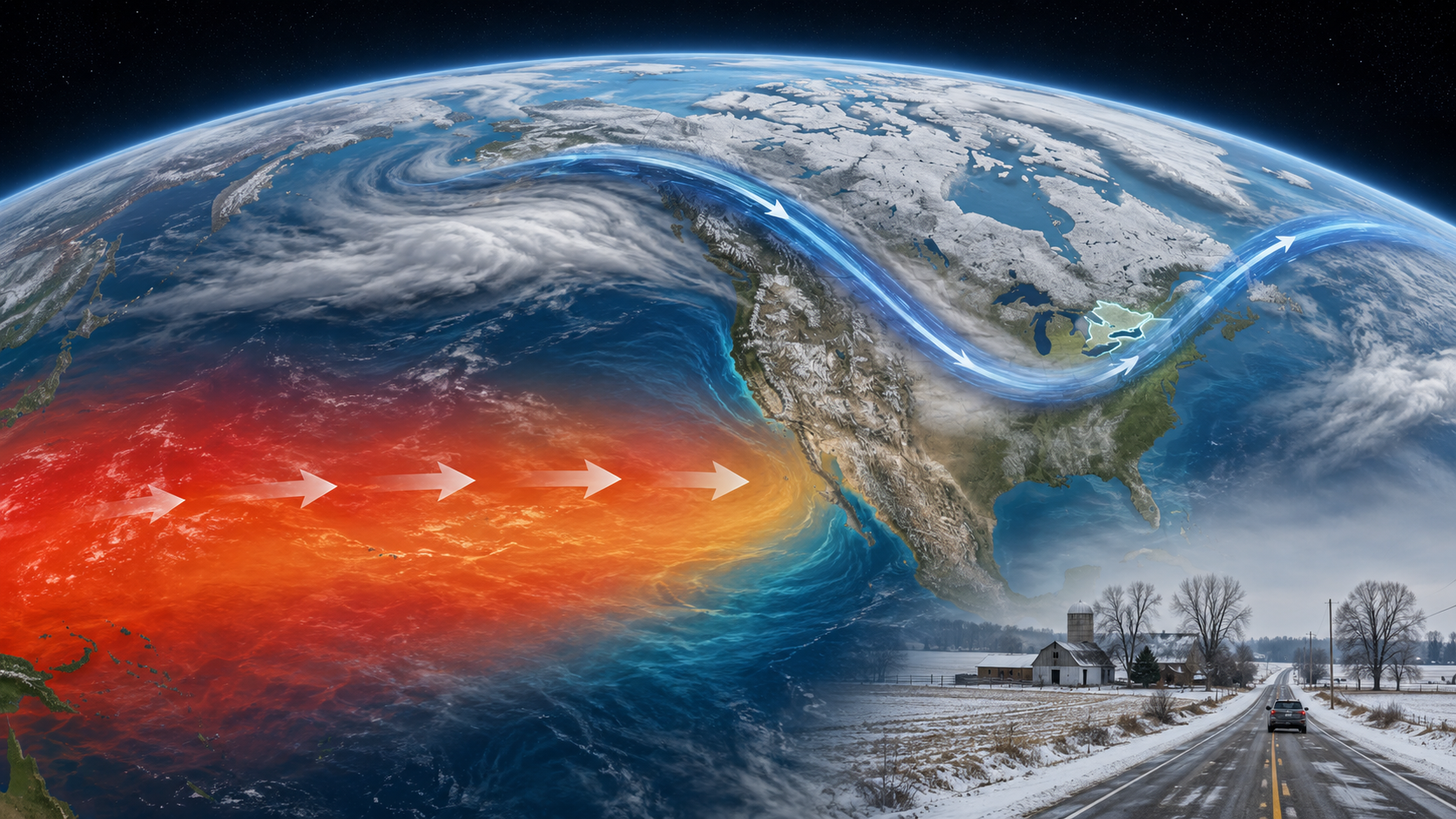
El Niño is strengthening in the tropical Pacific, and the 2026–27 event may become exceptionally powerful. That tilts the odds toward a milder, often drier Canadian winter—but it does not promise a snow-free season. In Southern Ontario, temperatures hovering near the freezing mark can trade deep cold for an awkward mixture of rain, wet snow, freezing rain, flash freezes and localized Great Lakes snow squalls.
What Is El Niño?
El Niño is the warm phase of the El Niño–Southern Oscillation, usually shortened to ENSO. ENSO is a natural cycle involving both the tropical Pacific Ocean and the atmosphere above it. Its three broad phases are El Niño, La Niña and neutral.
Under ordinary tropical Pacific conditions, easterly trade winds push warm surface water westward toward Indonesia and Australia. Along the Pacific coast of South America, colder, nutrient-rich water rises from below in a process called upwelling. The warmest water and the greatest thunderstorm activity are normally concentrated farther west.
During El Niño, those trade winds weaken and may partly reverse. Warm water spreads back toward the central and eastern equatorial Pacific, the thermocline—the boundary between warmer surface water and colder deep water—becomes deeper in the east, and cold-water upwelling is suppressed. Tropical rainfall and thunderstorm activity shift eastward as well.
Normal Pacific
Stronger easterly trade winds pile warm surface water in the western Pacific. Cold water rises near South America, and tropical convection stays farther west.
El Niño Pacific
Weaker trade winds allow warm water to spread east. Upwelling weakens, and the main zone of tropical heat and thunderstorms shifts toward the central and eastern Pacific.
This tropical change matters to Canada because towering thunderstorms release enormous amounts of heat into the upper atmosphere. Moving that heat source changes large-scale pressure patterns and influences the polar and subtropical jet streams. Jet streams steer storm tracks and help determine which regions receive Arctic air, Pacific air, snow or rain.
The Government of Canada notes that El Niño occurs roughly every two to seven years. Events commonly develop during spring or summer, peak between late fall and winter, and fade the following year. No two events are identical: strength, timing, location of the warmest water, Arctic circulation, Great Lakes temperatures and other ocean patterns all influence the final result.
What Is Different About the 2026–27 El Niño?
This is no longer merely a prediction that El Niño might form. NOAA reported on 13 August 2026 that the coupled ocean–atmosphere system was already showing a strengthening El Niño. July’s Niño-3.4 index was 1.4°C above the relevant average, while parts of the eastern equatorial Pacific were more than 2°C warmer than average. NOAA expects the event to strengthen through the end of 2026 and persist through winter.
The World Meteorological Organization also reported that a strong event was developing, while emphasizing that seasonal maps show the most likely category, not a certain outcome. “Very strong” describes the temperature anomaly in a defined tropical Pacific region; it does not mean every Canadian community will experience extreme weather.
A forecast is a tilt in the odds
Think of El Niño as loading the atmospheric dice. It makes some broad patterns more likely, but individual storms still depend on short-term conditions that seasonal models cannot resolve months ahead. A winter can average milder than normal and still include a severe cold snap. Seasonal snowfall can finish below normal even after one crippling storm. A drier average can include a damaging ice storm.
It is therefore too early to predict the number of snow days in Chatham-Kent, the timing of an ice storm along Highway 401 or the exact planting date for a farm near Lake Erie. Those details require short-range forecasts. El Niño offers a useful planning background—not a day-by-day script.
How El Niño Typically Affects Canadian Weather
Canada tends to feel El Niño most clearly in winter and spring. Environment and Climate Change Canada describes the broad North American pattern as a southward-shifted subtropical storm track and relatively milder, drier conditions across much of Canada. Historical composites show the strongest and most consistent warmth across Western, Northwestern and Central Canada, while Eastern Canada’s response is less reliable.
| Region | Typical El Niño tendency | Important limitation |
|---|---|---|
| British Columbia and the western mountains | Milder winter, reduced mountain snowpack in many areas and fewer cold outbreaks | Individual Pacific storms can still bring heavy rain, wind and mountain snow |
| Prairies | Milder and often drier, with fewer or shorter periods of severe Arctic cold | Dryness and low snow cover can reduce spring soil-moisture recharge |
| Northern and Central Canada | One of the more dependable warm signals, especially around parts of Hudson Bay | “Milder than normal” remains cold by southern Canadian standards |
| Ontario and Quebec | Greater chance of above-normal winter temperature; precipitation signal is less dependable | Storm track, Great Lakes and freeze–thaw timing can produce sharp local differences |
| Atlantic Canada | Often a weaker direct ENSO influence | Coastal storms and other climate patterns may overpower the El Niño signal |
Across Canada, reduced snowpack can matter long after winter. Snow stores water and releases it during spring melt. A small snowpack or early melt can reduce runoff and soil-moisture recharge, affect reservoirs and streams, and allow vegetation and crop residue to dry sooner. Conversely, fewer extreme cold episodes may lower heating demand and reduce some cold-related stress on livestock and infrastructure.
What the 2026–27 El Niño Could Mean for Southern Ontario
Historical El Niño maps published by Environment and Climate Change Canada place Southern Ontario among areas that can average roughly 2°C to 4°C warmer in an El Niño winter composite. That is a historical relationship—not a precise forecast for the coming winter—but it illustrates why the probability of a mild seasonal average deserves attention.
1. More time near the freezing point
Southern Ontario already spends much of winter near 0°C. Raising the average does not simply replace every snowflake with harmless rain. It increases the number of storms in which a small temperature difference determines whether precipitation falls as rain, wet snow, ice pellets or freezing rain. Temperatures can rise above freezing during the day and fall below it after sunset, creating repeated freeze–thaw cycles.
2. A greater chance of rain or mixed precipitation
If mild air reaches farther north during a storm, snow may change to ice pellets, freezing rain or rain. Inland valleys and sheltered areas can retain subfreezing surface air after warmer air arrives aloft—the classic setup for freezing rain. Wet snow may also be heavier and more adhesive, increasing loads on branches and overhead lines.
3. Potentially less seasonal snow—but not everywhere
A milder winter often reduces the fraction of precipitation that falls as snow and shortens how long snow remains on the ground. Yet lake-effect snow depends on cold air moving over relatively warm, open Great Lakes. A mild start can delay lake ice, leaving more open water available when an Arctic outbreak finally arrives. That can support intense, localized snow bands even during an otherwise mild winter.
The snowbelt east of Lake Huron and Georgian Bay, parts of the Bruce Peninsula, Huron, Perth, Grey, Simcoe and areas southeast of Georgian Bay can therefore experience a very different winter from communities only a short drive away. Southwestern corridors near Lake Huron and Lake Erie can also see sudden visibility changes under streamers or squalls.
4. More winter rainfall and runoff episodes
Rain falling on frozen or saturated ground cannot infiltrate readily. If rain combines with melting snow, water may collect in low fields, overwhelm drainage, raise streams and wash across rural roads. A subsequent temperature drop can turn standing water and slush into ice within hours.
Winter Travel: Why a Milder El Niño Winter Can Still Be Dangerous

Black ice and flash freezes
A wet road can look merely damp until pavement temperature falls below freezing. Bridges, overpasses, shaded concessions and exposed rural highways cool first. A flash freeze can occur when temperature drops quickly after rain or melting snow, turning untreated pavement into ice before drivers recognize the change.
Freezing rain
Freezing rain creates a smooth glaze that can be more difficult to drive on than packed snow. It can also bring down trees and power lines, interrupt traffic signals and close rural roads. A strong El Niño does not guarantee freezing rain, but more frequent near-zero storm profiles make mixed precipitation an important planning risk.
Wet, heavy snow
Snow falling just below freezing contains more liquid water than powdery snow in deep cold. It compacts into heavy slush, increases stopping distance and can pull vehicles toward the shoulder. It is harder on snow-removal equipment and can freeze solid after the storm.
Lake-effect snow squalls
A highway can go from bare pavement to near-whiteout conditions within minutes under a narrow squall. The danger is not only snowfall depth; it is the abrupt loss of visibility and contrast. Open fields allow blowing snow to cross roads, while traffic ahead may brake suddenly.
Practical winter travel checklist
- Use winter tires and check tread depth, pressure, wipers, washer fluid, battery condition, lights and defrosters before winter.
- Check Environment Canada warnings and Ontario 511 immediately before departure; seasonal expectations are never a substitute for the current forecast.
- Slow down before bridges and shaded sections. Avoid cruise control on wet, snowy or icy roads.
- Increase following distance substantially and make steering, braking and throttle inputs gradually.
- During a snow squall, postpone travel when possible. If caught, reduce speed smoothly, keep lights on and avoid stopping in a live lane.
- Carry warm clothing, boots, gloves, a phone charger, scraper, shovel, traction aid, flashlight and emergency supplies suitable for rural delays.
- For commercial vehicles, drain and maintain air systems, verify air-dryer operation, protect exposed electrical connections and inspect tires and brakes with repeated slush-and-freeze cycles in mind.
How El Niño Could Affect Southern Ontario Agriculture
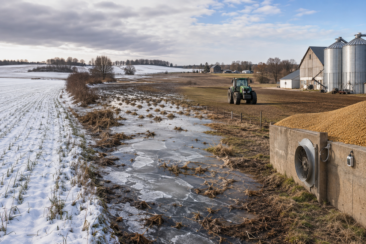
Southern Ontario agriculture is diverse: corn, soybeans, winter wheat, forage, vegetables, orchards, vineyards, greenhouses, dairy, beef, pork and poultry do not respond to winter weather in the same way. The most useful approach is to consider specific pathways rather than assume that “mild” automatically means favourable.
Winter wheat and forage: less snow cover can expose crowns
A stable snow layer insulates overwintering wheat and perennial forage from sharp temperature swings. A mild, open winter can leave plant crowns exposed when cold air briefly returns. Repeated thawing and refreezing may contribute to heaving, in which ice movement lifts plants and damages roots. Water ponded in depressions can freeze into an ice sheet, restrict gas exchange and injure plants.
The risk is field-specific. Well-drained ground with healthy, well-established plants may come through well, while compacted headlands and low areas can show winterkill. Spring assessment should look for living crown tissue and new root growth rather than judge plants only by brown leaves.
Soil structure, erosion and nutrient loss
Winter rain on frozen or saturated soil can run off rather than soak in. Bare fields and sloping ground are more vulnerable to erosion. Surface-applied nutrients or manure may move with runoff if application timing, soil condition and weather are unfavourable. Freeze–thaw cycles can improve tilth in some heavy soils, but traffic on wet ground can undo that benefit through compaction and rutting.
Maintain residue or cover where possible, keep grassed waterways and outlets open, inspect tile-drainage trouble spots, and follow Ontario requirements and nutrient-management plans. Avoid assuming a mild day means the soil profile is fit for manure spreading or equipment.
Spring field access and planting
An early warm spell can thaw the surface while the subsoil remains frozen, leaving water perched above it. Machinery may travel on top initially and then sink as the frost leaves. Entering too early can create sidewall compaction, ruts and a dense layer that restricts roots throughout the growing season.
On the positive side, a genuinely early, dry spring may expand the fieldwork window and allow timely planting. Agriculture and Agri-Food Canada notes that warmer springs can lengthen the growing season, but wetter springs can delay seeding through waterlogging and increase erosion and nutrient runoff. Soil fitness—not the calendar—should decide the start.
Soil moisture and the 2027 growing season
A winter with less snow or more midwinter runoff may provide less gradual recharge at spring melt. If spring also turns dry, shallow-rooted crops, pastures and newly seeded fields can face moisture stress earlier. Tile-drained farms can still experience low available water later because tile controls excess water; it does not replace rainfall.
The opposite outcome is also possible: repeated winter rain and a wet spring can delay operations. Farmers should monitor precipitation, snow-water equivalent, tile flow and soil moisture rather than infer spring conditions from temperature alone.
Pests, diseases and weeds
Deep, persistent cold suppresses some insects, pathogens and weeds. A milder winter can improve survival of certain pests, although snow cover, soil temperature and moisture often matter more than air temperature. Earlier spring warmth may advance insect emergence and weed growth. Scouting should begin according to accumulated heat and field conditions, not simply last year’s date.
Fruit trees, vineyards and maple production
Warm spells can reduce dormancy and advance bud development. If a later freeze follows, tender buds may be damaged. The risk is especially important for peaches, tender fruit, grapes and early-blooming cultivars in Niagara and the north shore of Lake Erie. More variable spring temperatures can also compress maple syrup season: sap flow requires freezing nights and thawing days, and prolonged warmth can end the season early.
Livestock and farm infrastructure
Fewer extreme-cold days may reduce heating demand, water-line freezing and cold stress. However, mud, humidity and repeated freeze–thaw conditions create their own problems: slippery yards, hoof issues, bedding demand, manure-storage pressure and fluctuating barn ventilation. Heavy wet snow or freezing rain can load roofs, trees and electrical lines even in an otherwise mild winter.
Stored grain
Frequent temperature swings can encourage moisture migration and condensation in grain bins. Stored corn and soybeans should be checked for temperature changes, crusting, odour and insects. Aeration decisions should be based on grain temperature, equilibrium moisture and outside-air conditions—not simply a warm afternoon.
What Farmers and Rural Property Owners Can Do Now
- Inspect drainage: clear legal outlets, culverts, surface inlets and known tile restrictions before freeze-up.
- Map vulnerable areas: note winter wheat low spots, erosion channels, yards prone to glazing and roads that drift or flood.
- Protect soil: retain crop residue, establish suitable cover crops and avoid unnecessary traffic when wet.
- Review stored-grain routines: calibrate temperature cables or probes and confirm fans, vents and controls operate correctly.
- Prepare backup power: test generators and transfer equipment for livestock ventilation, water, heat and critical controls.
- Service winter equipment: inspect snow-removal machinery, tire chains where used, batteries, coolant protection, fuel systems and emergency lighting.
- Plan flexible field operations: secure seed, fertilizer and custom-work arrangements, but retain room to adjust to soil fitness and actual spring moisture.
- Use official updates: follow Environment and Climate Change Canada for seasonal forecasts and warnings, and Agriculture and Agri-Food Canada for agroclimate and drought reporting.
The Bottom Line
The 2026–27 El Niño is strengthening and may rank among the most powerful in the modern record. For Canada, that increases the likelihood of a milder winter, particularly across western and central regions. Southern Ontario may also lean mild, but its location near the Great Lakes and the freezing point makes the details complicated.
Residents should prepare for variability rather than assume winter has been cancelled: rain changing to ice, quick freezes after thawing, wet snow, localized snow squalls and rapid road deterioration can all occur within a mild season. Farmers may benefit from fewer deep-cold episodes or an earlier spring, yet face reduced protective snow cover, ponding, erosion, winterkill, pest survival, muddy livestock areas, stored-grain moisture problems and soil compaction if fields are worked prematurely.
El Niño changes the odds; it does not write the forecast. The best decisions will combine seasonal awareness with local soil observations, short-range forecasts and official warnings throughout winter and spring.
Authoritative Sources and Further Reading
- NOAA Climate Prediction Center — ENSO Diagnostic Discussion, 13 August 2026
- Environment and Climate Change Canada — El Niño and its impacts in Canada
- World Meteorological Organization — Strong El Niño expected to intensify, 31 July 2026
- Agriculture and Agri-Food Canada — Climate change impacts on agriculture
- Agriculture and Agri-Food Canada — National Agroclimate Risk Report
Forecast information is current to 19 August 2026 and should be updated as new monthly ENSO and Canadian seasonal outlooks are issued.
Leave a Reply